
Mapa topográfico Limuru
Mapa interactivo
Haga clic en el mapa para ver la altitud.
Limuru
Most of the area of Limuru is now what was previously known as the "white highlands", a rich agricultural land south of the equator. The term "white highlands" derived from the British and other Europeans who realised the productive potential of this area and settled in large numbers with the support of the colonial government, establishing coffee and tea plantations, cereal farms and ranches. The altitude of the town is about 2,500 meters. Limuru has a temperature of 10–28 °C (75 °F) year round.
Acerca de este mapa
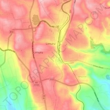
Nombre: Mapa topográfico Limuru, altitud, relieve.
Lugar: Limuru, Kiambu, Central Kenya, 00217, Kenya (-1.13824 36.61197 -1.10382 36.66160)
Altitud media: 2.254 m
Altitud mínima: 2.132 m
Altitud máxima: 2.319 m
Otros mapas topográficos
Haga clic en un mapa para ver su topografía, su altitud y su relieve.