
Mapa topográfico Durango
Mapa interactivo
Haga clic en el mapa para ver la altitud.
Acerca de este mapa
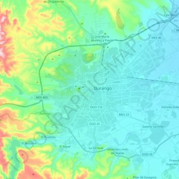
Nombre: Mapa topográfico Durango, altitud, relieve.
Lugar: Durango, Mexico (23.94563 -104.73078 24.09514 -104.51793)
Altitud media: 1.954 m
Altitud mínima: 1.861 m
Altitud máxima: 2.348 m
With 123,451.2 km2 or 12.3 million ha, Durango accounts for about 6.3% of the entire territory of Mexico. It is the fourth largest state lying at the extreme northwest of the Central Mexican Plateau, where it meets the Sierra Madre Occidental—the highest peaks in the state. The state has an average elevation of 1,775 meters above sea level, with a mean elevation of 1,750 m in the Valleys region and 2,450 m in the Sierra region. The city of Durango is on the foothills of the Sierra Madre Occidental, with an elevation of 1,857 m.