
Mapa topográfico Adjud
Mapa interactivo
Haga clic en el mapa para ver la altitud.
Acerca de este mapa
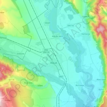
Nombre: Mapa topográfico Adjud, altitud, relieve.
Lugar: Adjud, Vrancea, Romania (46.04291 27.12362 46.18147 27.25442)
Altitud media: 138 m
Altitud mínima: 77 m
Altitud máxima: 371 m
Adjud is situated on a plain and is surrounded by hills up to a height of 400 meters at the foot of the southern Carpathians. The average altitude of the town is 100 m above sea level. The surrounding land is favorable for agriculture.
Otros mapas topográficos
Haga clic en un mapa para ver su topografía, su altitud y su relieve.