
Mapa topográfico Attendorn
Mapa interactivo
Haga clic en el mapa para ver la altitud.
Acerca de este mapa
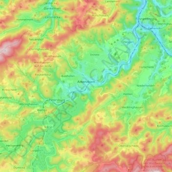
Nombre: Mapa topográfico Attendorn, altitud, relieve.
Lugar: Attendorn, Kreis Olpe, North Rhine-Westphalia, 57439, Germany (51.07271 7.79579 51.17069 8.00401)
Altitud media: 384 m
Altitud mínima: 229 m
Altitud máxima: 630 m
The town of Attendorn lies in the Naturpark Ebbegebirge, right on the Biggesee (lake) in the district's northwest. The town's highest point is the Rüenhardt (636 m), whereas the Ahauser Stausee (reservoir) has an elevation of only 248 m. The municipal area comprises 97 km², roughly half of which is wooded. It is a part of South Westphalia.
Otros mapas topográficos
Haga clic en un mapa para ver su topografía, su altitud y su relieve.
Waare
Germany > North Rhine-Westphalia > Kreis Olpe > Kirchhundem
Waare, Kirchhundem, Kreis Olpe, North Rhine-Westphalia, Germany
Altitud media: 497 m
Balzenberg
Germany > North Rhine-Westphalia > Kreis Olpe > Wenden
Balzenberg, Wenden, Kreis Olpe, North Rhine-Westphalia, 57482, Germany
Altitud media: 397 m
Meggen
Germany > North Rhine-Westphalia > Kreis Olpe > Lennestadt
Meggen, Lennestadt, Kreis Olpe, North Rhine-Westphalia, 57368, Germany
Altitud media: 369 m
Olpe
Germany > North Rhine-Westphalia > Kreis Olpe > Olpe
Olpe, Kreis Olpe, North Rhine-Westphalia, 57462, Germany
Altitud media: 400 m
Rüblinghausen
Germany > North Rhine-Westphalia > Kreis Olpe > Olpe > Rüblinghausen
Rüblinghausen, Olpe, Kreis Olpe, North Rhine-Westphalia, 57462, Germany
Altitud media: 371 m
Lennestadt
Germany > North Rhine-Westphalia > Kreis Olpe > Lennestadt
Lennestadt, Kreis Olpe, North Rhine-Westphalia, 57368, Germany
Altitud media: 422 m