
Mapa topográfico Lake Turkana
Mapa interactivo
Haga clic en el mapa para ver la altitud.
Acerca de este mapa
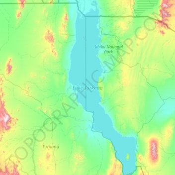
Nombre: Mapa topográfico Lake Turkana, altitud, relieve.
Lugar: Lake Turkana, Marsabit County, Eastern, Kenya (2.39737 35.82914 4.65387 36.70775)
Altitud media: 590 m
Altitud mínima: 358 m
Altitud máxima: 2.270 m
The rocks of the surrounding area are predominantly volcanic. Central Island is an active volcano, emitting vapour. Outcrops and rocky shores are found on the east and south shores of the lake, while dunes, spits and flats are on the west and north, at a lower elevation.
Otros mapas topográficos
Haga clic en un mapa para ver su topografía, su altitud y su relieve.
Korr
Kenya > Marsabit County > Korr/Ngurunit ward
Korr, Korr/Ngurunit ward, Marsabit County, Eastern, Kenya
Altitud media: 552 m
Gatab
Kenya > Marsabit County > Loiyangalani ward
Gatab, Loiyangalani ward, Marsabit County, Eastern, Kenya
Altitud media: 1.610 m
Yaa Algana
Kenya > Marsabit County > North Horr > Dukana
Yaa Algana, Dukana, North Horr, Marsabit County, Eastern, Kenya
Altitud media: 491 m
Dabel
Kenya > Marsabit County > Moyale > Golobo ward
Dabel, Golobo ward, Moyale, Marsabit County, Eastern, Kenya
Altitud media: 654 m
Kargi
Kenya > Marsabit County > Laisamis > Kargi/South Horr ward
Kargi, Kargi/South Horr ward, Laisamis, Marsabit County, Eastern, Kenya
Altitud media: 418 m