
Mapa topográfico Denniston
Mapa interactivo
Haga clic en el mapa para ver la altitud.
Acerca de este mapa
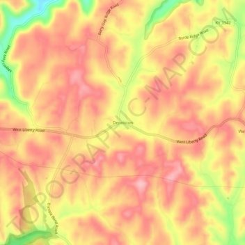
Nombre: Mapa topográfico Denniston, altitud, relieve.
Lugar: Denniston, Menifee County, Kentucky, 40316, United States (37.89592 -83.55796 37.93592 -83.51796)
Altitud media: 357 m
Altitud mínima: 261 m
Altitud máxima: 403 m
Otros mapas topográficos
Haga clic en un mapa para ver su topografía, su altitud y su relieve.
Cave Run Lake
United States > Kentucky > Menifee County
Cave Run Lake, Menifee County, Kentucky, United States
Altitud media: 297 m
Scranton
United States > Kentucky > Menifee County
Scranton, Menifee County, Kentucky, United States
Altitud media: 295 m