
Mapa topográfico Cedar Hill
Mapa interactivo
Haga clic en el mapa para ver la altitud.
Acerca de este mapa
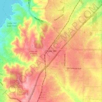
Nombre: Mapa topográfico Cedar Hill, altitud, relieve.
Lugar: Cedar Hill, Dallas County, Texas, 75104-2135, United States (32.54881 -96.99537 32.62881 -96.91537)
Altitud media: 225 m
Altitud mínima: 156 m
Altitud máxima: 268 m
It is sometimes referred to as the "hill country of Dallas" (in comparison to the "hill country" surrounding Austin and San Antonio). The city is full of native eastern red cedar evergreen trees and stands at an elevation of about 800 feet (240 m) above sea level—the highest point in a straight line from the Red River at the Texas-Oklahoma border to the Gulf Coast.