
Mapa topográfico Dolores Hidalgo
Mapa interactivo
Haga clic en el mapa para ver la altitud.
Acerca de este mapa
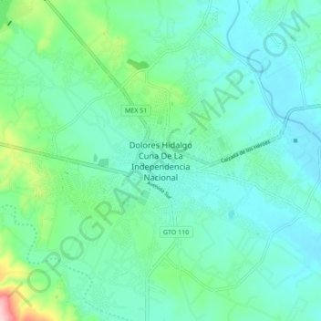
Nombre: Mapa topográfico Dolores Hidalgo, altitud, relieve.
Lugar: Dolores Hidalgo, Guanajuato, 37800, Mexico (21.11740 -100.97462 21.19740 -100.89462)
Altitud media: 1.938 m
Altitud mínima: 1.893 m
Altitud máxima: 2.124 m
It is located at 21°10′N 100°56′W / 21.17°N 100.93°W / 21.17; -100.93, at an elevation of about 1,980 meters (6,480 feet) above sea level. In the census of 2005 the city had a population of 54,843, while the municipality had 134,641 inhabitants. The city lies directly in the center of the municipality, which is 1,656 km2 (639 sq mi) in area and includes numerous small outlying communities, the largest of which is Río Laja with a population of 2,211 (2005 census).