
Mapa topográfico Saarwellingen
Mapa interactivo
Haga clic en el mapa para ver la altitud.
Acerca de este mapa
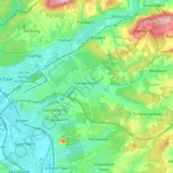
Nombre: Mapa topográfico Saarwellingen, altitud, relieve.
Lugar: Saarwellingen, Landkreis Saarlouis, Saarland, 66793, Germany (49.31680 6.76382 49.38441 6.92215)
Altitud media: 235 m
Altitud mínima: 173 m
Altitud máxima: 407 m
Otros mapas topográficos
Haga clic en un mapa para ver su topografía, su altitud y su relieve.
Schwalbach
Germany > Saarland > Landkreis Saarlouis
Schwalbach, Landkreis Saarlouis, Saarland, 66773, Germany
Altitud media: 236 m
Michelbach
Germany > Saarland > Landkreis Saarlouis
Michelbach, Schmelz, Landkreis Saarlouis, Saarland, 66839, Germany
Altitud media: 288 m
Saarlouis
Germany > Saarland > Landkreis Saarlouis > Saarlouis
Saarlouis, Landkreis Saarlouis, Saarland, 66740, Germany
Altitud media: 222 m