
Mapa topográfico Murang'a
Mapa interactivo
Haga clic en el mapa para ver la altitud.
Murang'a
The town is low, a bit hilly, small but picturesque with an altitude of 4120 ft (1255 metres) above sea level. As a result of the varying altitudes, Murang'a can get quite cold from May to mid-August, and can experience hail. To the west of the town can be seen the rolling Kikuyu farmlands that extend as far as the eyes can see.
Acerca de este mapa
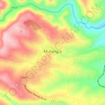
Nombre: Mapa topográfico Murang'a, altitud, relieve.
Lugar: Murang'a, Kiharu, Murang'a County, Central Kenya, 10200, Kenya (-0.73750 37.13963 -0.71061 37.17323)
Altitud media: 1.286 m
Altitud mínima: 1.161 m
Altitud máxima: 1.387 m