
Mapa topográfico Bainbridge Island
Haga clic en el mapa para ver la altitud.
Bainbridge Island
Bainbridge Island is characterized by diverse topography shaped by glacial activity during the last Ice Age. The island features gently rolling hills interspersed with flat lowlands and steep coastal bluffs. Elevations range from sea level along the shoreline to about 425 feet at its highest points, with terrain marked by deposits from the Vashon Glaciation, including glacial till and outwash plains. Numerous small valleys and ravines, carved by streams and erosion, crisscross the landscape. The coastline is varied, with rocky promontories, sandy beaches, and tidal inlets, adding to the island’s intricate terrain and natural beauty.
Acerca de este mapa
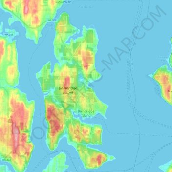
Nombre: Mapa topográfico Bainbridge Island, altitud, relieve.
Altitud media: 24 m
Altitud mínima: -5 m
Altitud máxima: 151 m
Otros mapas topográficos
Haga clic en un mapa para ver su topografía, su altitud y su relieve.