
Mapa topográfico Stevensville
Mapa interactivo
Haga clic en el mapa para ver la altitud.
Acerca de este mapa
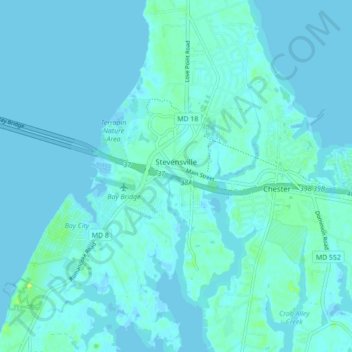
Nombre: Mapa topográfico Stevensville, altitud, relieve.
Lugar: Stevensville, Queen Anne's County, Maryland, United States (38.94386 -76.35551 39.01179 -76.28974)
Altitud media: 2 m
Altitud mínima: -2 m
Altitud máxima: 16 m
Otros mapas topográficos
Haga clic en un mapa para ver su topografía, su altitud y su relieve.
Kent Island
United States > Maryland > Queen Anne's County > Chester
Kent Island, Chester, Queen Anne's County, Maryland, United States
Altitud media: 1 m
Tuckahoe State Park
United States > Maryland > Queen Anne's County > Waljacks Corners
Tuckahoe State Park, Queen Anne Highway, Waljacks Corners, Queen Anne's County, Maryland, 21657, United States
Altitud media: 17 m
Chester
United States > Maryland > Queen Anne's County > Chester
Chester, Queen Anne's County, Maryland, United States
Altitud media: 2 m
Centreville
United States > Maryland > Queen Anne's County
Centreville, Queen Anne's County, Maryland, United States
Altitud media: 15 m
Grasonville
United States > Maryland > Queen Anne's County
Grasonville, Queen Anne's County, Maryland, 21638, United States
Altitud media: 3 m