
Mapa topográfico Bunia
Mapa interactivo
Haga clic en el mapa para ver la altitud.
Acerca de este mapa
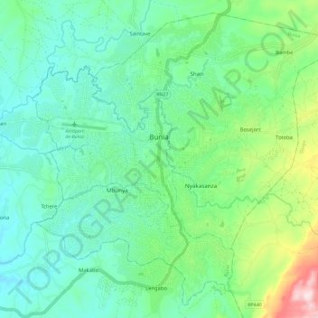
Nombre: Mapa topográfico Bunia, altitud, relieve.
Lugar: Bunia, Ituri, Democratic Republic of the Congo (1.50098 30.20198 1.60705 30.31717)
Altitud media: 1.273 m
Altitud mínima: 1.156 m
Altitud máxima: 1.636 m
It lies at an elevation of 1,275 metres or 4,180 feet on a plateau about 30 kilometres or 19 miles west of Lake Albert in the Albertine Rift, and about 25 kilometres or 16 miles east of the Ituri Rainforest.
Otros mapas topográficos
Haga clic en un mapa para ver su topografía, su altitud y su relieve.
Epau
Democratic Republic of the Congo > Ituri > Aru
Epau, Aru, Ituri, Democratic Republic of the Congo
Altitud media: 1.249 m
Bulo
Democratic Republic of the Congo > Ituri > Djugu
Bulo, Djugu, Ituri, Democratic Republic of the Congo
Altitud media: 2.064 m
Lebia
Democratic Republic of the Congo > Ituri > Lebia
Lebia, Orientale, Ituri, Democratic Republic of the Congo
Altitud media: 901 m
Amee
Democratic Republic of the Congo > Ituri > Amee
Amee, Orientale, Ituri, Democratic Republic of the Congo
Altitud media: 1.844 m
Shari
Democratic Republic of the Congo > Ituri > Bunia
Shari, Bunia, Irumu, Orientale, Ituri, Democratic Republic of the Congo
Altitud media: 1.005 m