
Mapa topográfico Bel Aire
Mapa interactivo
Haga clic en el mapa para ver la altitud.
Acerca de este mapa
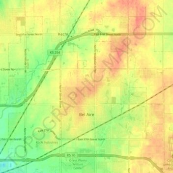
Nombre: Mapa topográfico Bel Aire, altitud, relieve.
Lugar: Bel Aire, Sedgwick County, Kansas, United States (37.75229 -97.28077 37.79596 -97.18976)
Altitud media: 424 m
Altitud mínima: 396 m
Altitud máxima: 444 m
Bel Aire is located at 37°45′50″N 97°15′58″W / 37.76389°N 97.26611°W / 37.76389; -97.26611 (37.763758, −97.266177) at an elevation of 1,394 feet (425 m). It lies on the north side of the East Fork of Chisholm Creek roughly 6 mi (9.7 km) northeast of the Arkansas River in the Wellington-McPherson Lowlands region of the Great Plains. Located on the south side of K-254 in south-central Kansas, Bel Aire is within the Wichita metropolitan area, bordered by Wichita to the south and west and bordered by Kechi to the north.
Otros mapas topográficos
Haga clic en un mapa para ver su topografía, su altitud y su relieve.
Wichita
United States > Kansas > Sedgwick County
Wichita, Sedgwick County, Kansas, United States
Altitud media: 408 m
Colwich
United States > Kansas > Sedgwick County
Colwich, Sedgwick County, Kansas, United States
Altitud media: 421 m
Mulvane
United States > Kansas > Sedgwick County
Mulvane, Sedgwick County, Kansas, 67110, United States
Altitud media: 386 m
Wichita
United States > Kansas > Sedgwick County > Wichita
Wichita, Sedgwick County, Kansas, 67202, United States
Altitud media: 410 m
Andale
United States > Kansas > Sedgwick County
Andale, Sedgwick County, Kansas, United States
Altitud media: 440 m
Kechi
United States > Kansas > Sedgwick County
Kechi, Sedgwick County, Kansas, United States
Altitud media: 429 m
Garden Plain
United States > Kansas > Sedgwick County
Garden Plain, Sedgwick County, Kansas, United States
Altitud media: 444 m
Maize
United States > Kansas > Sedgwick County
Maize, Sedgwick County, Kansas, United States
Altitud media: 414 m
Valley Center
United States > Kansas > Sedgwick County
Valley Center, Sedgwick County, Kansas, United States
Altitud media: 413 m
Park City
United States > Kansas > Sedgwick County
Park City, Sedgwick County, Kansas, United States
Altitud media: 421 m
Haysville
United States > Kansas > Sedgwick County
Haysville, Riverside Township, Sedgwick County, Kansas, United States
Altitud media: 388 m
Minneha
United States > Kansas > Sedgwick County > Wichita
Minneha, Wichita, Sedgwick County, Kansas, 67206, United States
Altitud media: 423 m
Valley Center
United States > Kansas > Sedgwick County > Valley Center > Valley Center
Valley Center, Sedgwick County, Kansas, United States
Altitud media: 415 m
Derby
United States > Kansas > Sedgwick County
Derby, Sedgwick County, Kansas, 67037, United States
Altitud media: 393 m
Mount Hope
United States > Kansas > Sedgwick County > Mount Hope
Mount Hope, Sedgwick County, Kansas, United States
Altitud media: 439 m