
Mapa topográfico Cecil Park
Mapa interactivo
Haga clic en el mapa para ver la altitud.
Acerca de este mapa
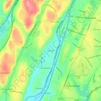
Nombre: Mapa topográfico Cecil Park, altitud, relieve.
Altitud media: 70 m
Altitud mínima: 29 m
Altitud máxima: 123 m
Otros mapas topográficos
Haga clic en un mapa para ver su topografía, su altitud y su relieve.
Park Hill
United States > New York > Westchester County > City of Yonkers
Park Hill, City of Yonkers, Westchester County, New York, 10705, United States
Altitud media: 43 m
Colonial Heights
United States > New York > Westchester County > City of Yonkers
Colonial Heights, City of Yonkers, Westchester County, New York, 10710, United States
Altitud media: 60 m
Grey Oaks
United States > New York > Westchester County > City of Yonkers
Grey Oaks, City of Yonkers, Westchester County, New York, 10703, United States
Altitud media: 60 m
Lowerre
United States > New York > Westchester County > City of Yonkers
Lowerre, City of Yonkers, Westchester County, New York, 10705, United States
Altitud media: 34 m
Crestwood Gardens
United States > New York > Westchester County > City of Yonkers
Crestwood Gardens, City of Yonkers, Westchester County, New York, 10707, United States
Altitud media: 65 m
Gunther Park
United States > New York > Westchester County > City of Yonkers
Gunther Park, City of Yonkers, Westchester County, New York, 10704, United States
Altitud media: 56 m
Bronxville Heights
United States > New York > Westchester County > City of Yonkers
Bronxville Heights, City of Yonkers, Westchester County, New York, 10710, United States
Altitud media: 63 m
Nepperhan
United States > New York > Westchester County > City of Yonkers
Nepperhan, City of Yonkers, Westchester County, New York, 10703, United States
Altitud media: 64 m