
Mapa topográfico Sand Hill
Mapa interactivo
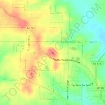
Haga clic en el mapa para ver la altitud.
Acerca de este mapa
Nombre: Mapa topográfico Sand Hill, altitud, relieve.
Altitud media: 118 m
Altitud mínima: 84 m
Altitud máxima: 150 m
Otros mapas topográficos
Haga clic en un mapa para ver su topografía, su altitud y su relieve.
Pocahontas
United States > Arkansas > Randolph County > Pocahontas
Pocahontas, Randolph County, Arkansas, United States
Altitud media: 96 m
Pocahontas
United States > Arkansas > Randolph County > Pocahontas
Pocahontas, Randolph County, Arkansas, 72455, United States
Altitud media: 94 m