
Mapa topográfico Brooklet
Mapa interactivo
Haga clic en el mapa para ver la altitud.
Acerca de este mapa
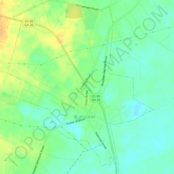
Nombre: Mapa topográfico Brooklet, altitud, relieve.
Lugar: Brooklet, Bulloch County, Georgia, United States (32.36631 -81.68509 32.40664 -81.64489)
Altitud media: 49 m
Altitud mínima: 37 m
Altitud máxima: 65 m
Otros mapas topográficos
Haga clic en un mapa para ver su topografía, su altitud y su relieve.
Portal
United States > Georgia > Bulloch County
Portal, Bulloch County, Georgia, United States
Altitud media: 85 m
Lakeview Estates
United States > Georgia > Bulloch County > Statesboro
Lakeview Estates, Statesboro, Bulloch County, Georgia, 30459, United States
Altitud media: 65 m
Brians Chase
United States > Georgia > Bulloch County > Statesboro
Brians Chase, Statesboro, Bulloch County, Georgia, 30461, United States
Altitud media: 59 m
Register
United States > Georgia > Bulloch County
Register, Bulloch County, Georgia, United States
Altitud media: 57 m
Statesboro
United States > Georgia > Bulloch County
Statesboro, Bulloch County, Georgia, United States
Altitud media: 66 m