
Mapa topográfico Le Bois Josselin
Mapa interactivo
Haga clic en el mapa para ver la altitud.
Acerca de este mapa
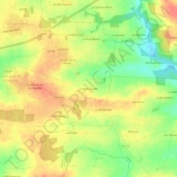
Nombre: Mapa topográfico Le Bois Josselin, altitud, relieve.
Altitud media: 88 m
Altitud mínima: 56 m
Altitud máxima: 110 m
Otros mapas topográficos
Haga clic en un mapa para ver su topografía, su altitud y su relieve.
La Grange Neuve
France > Bretagne > Morbihan > Ploërmel
La Grange Neuve, Ploërmel, Pontivy, Morbihan, Bretagne, France métropolitaine, 56800, France
Altitud media: 73 m
Le Clos Hazel
France > Bretagne > Morbihan > Ploërmel
Le Clos Hazel, Ploërmel, Pontivy, Morbihan, Bretagne, France métropolitaine, 56800, France
Altitud media: 59 m
La Croix aux Loups
France > Bretagne > Morbihan > Ploërmel
La Croix aux Loups, Ploërmel, Pontivy, Morbihan, Bretagne, France métropolitaine, 56800, France
Altitud media: 58 m
Le Champ des Oiseaux
France > Bretagne > Morbihan > Ploërmel
Le Champ des Oiseaux, Ploërmel, Pontivy, Morbihan, Bretagne, France métropolitaine, 56800, France
Altitud media: 56 m