
Mapa topográfico Longonot
Mapa interactivo
Haga clic en el mapa para ver la altitud.
Acerca de este mapa
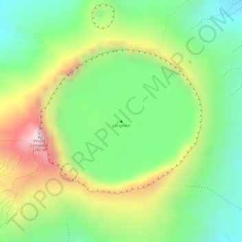
Nombre: Mapa topográfico Longonot, altitud, relieve.
Lugar: Longonot, Mai Mahiu ward, Naivasha, Nakuru, Rift Valley, Kenya (-0.91449 36.45641 -0.91439 36.45651)
Altitud media: 2.439 m
Altitud mínima: 2.210 m
Altitud máxima: 2.758 m
Mount Longonot is protected by Kenya Wildlife Service as part of Mount Longonot National Park. A 3.1 km trail runs from the park entrance up to the crater rim, and continues in a 7.2 km loop encircling the crater. The whole tour (gate-around the rim-gate) of 13.5 km takes about 4–5 hours allowing for necessary rest breaks - parts of the trail are heavily eroded and very steep. The gate elevation is around 2150 m and the peak at 2776 m but following the jagged rim involves substantially more than the 630 m vertical difference.
Otros mapas topográficos
Haga clic en un mapa para ver su topografía, su altitud y su relieve.
Jikaze
Kenya > Nakuru > Naivasha > Mai Mahiu ward
Jikaze, Mai Mahiu ward, Naivasha, Nakuru, Rift Valley, Kenya
Altitud media: 1.971 m