
Mapa topográfico Village of Hammond
Mapa interactivo
Haga clic en el mapa para ver la altitud.
Acerca de este mapa
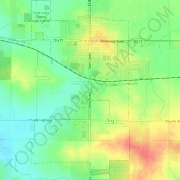
Nombre: Mapa topográfico Village of Hammond, altitud, relieve.
Altitud media: 342 m
Altitud mínima: 317 m
Altitud máxima: 374 m
Otros mapas topográficos
Haga clic en un mapa para ver su topografía, su altitud y su relieve.
Mount Hellen
United States > Wisconsin > Saint Croix County > Town of Saint Joseph
Mount Hellen, Town of Saint Joseph, Saint Croix County, Wisconsin, United States
Altitud media: 282 m
Hudson
United States > Wisconsin > Saint Croix County
Hudson, Saint Croix County, Wisconsin, 54016, United States
Altitud media: 243 m
Somerset
United States > Wisconsin > Saint Croix County > Somerset
Somerset, Saint Croix County, Wisconsin, 54025, United States
Altitud media: 273 m
Baldwin
United States > Wisconsin > Saint Croix County > Baldwin
Baldwin, Saint Croix County, Wisconsin, 54002, United States
Altitud media: 350 m
Town of Somerset
United States > Wisconsin > Saint Croix County
Town of Somerset, Saint Croix County, Wisconsin, United States
Altitud media: 279 m
Town of Hudson
United States > Wisconsin > Saint Croix County
Town of Hudson, Saint Croix County, Wisconsin, United States
Altitud media: 281 m
Roberts
United States > Wisconsin > Saint Croix County
Roberts, Saint Croix County, Wisconsin, United States
Altitud media: 313 m
New Richmond
United States > Wisconsin > Saint Croix County
New Richmond, Saint Croix County, Wisconsin, 54017, United States
Altitud media: 303 m
North Hudson
United States > Wisconsin > Saint Croix County
North Hudson, Saint Croix County, Wisconsin, United States
Altitud media: 230 m