
Mapa topográfico Mombasa
Mapa interactivo
Haga clic en el mapa para ver la altitud.
Acerca de este mapa
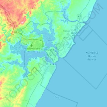
Nombre: Mapa topográfico Mombasa, altitud, relieve.
Lugar: Mombasa, Mvita, Mombasa County, Coastal Kenya, 80100, Kenya (-4.21052 39.50717 -3.89052 39.82717)
Altitud media: 32 m
Altitud mínima: -3 m
Altitud máxima: 262 m
Being a coastal town, Mombasa is characterised by a flat topography. The town of Mombasa is centred on Mombasa Island, but extends to the mainland. The island is separated from the mainland by two creeks, Port Reitz in the south and Tudor Creek in the north.
Otros mapas topográficos
Haga clic en un mapa para ver su topografía, su altitud y su relieve.
Tudor ward
Kenya > Mombasa County > Mvita > Tudor ward
Tudor ward, Mvita, Mombasa County, Coast, Kenya
Altitud media: 15 m