
Mapa topográfico Marbach am Neckar
Mapa interactivo
Haga clic en el mapa para ver la altitud.
Marbach am Neckar
The city (Stadt) of Marbach am Neckar covers 18.06 square kilometers (6.97 sq mi) of the district of Ludwigsburg in a total of four separate exclaves. Marbach is, according to government urban planning, part of the Stuttgart Metropolitan Region. Marbach's municipal areas are physically located in the basin of [de] the Neckar, with the exception of its easternmost exclave, which lies in the Swabian-Franconian Forest. The lowest elevation above sea level in the municipal area, 190 meters (620 ft) Normalnull (NN), is found where the Neckar flows out of Marbach and into Benningen am Neckar. The highest elevation, 355 meters (1,165 ft), is found in the east, at the top of the Bülzberg.
Acerca de este mapa
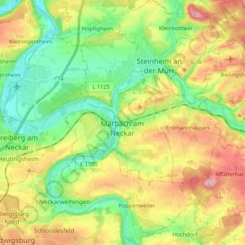
Nombre: Mapa topográfico Marbach am Neckar, altitud, relieve.
Altitud media: 251 m
Altitud mínima: 179 m
Altitud máxima: 355 m
Otros mapas topográficos
Haga clic en un mapa para ver su topografía, su altitud y su relieve.
Nussdorf
Germany > Baden-Württemberg > Landkreis Ludwigsburg
The municipality (Gemeinde) of Eberdingen is located at the western extremity of the district of Ludwigsburg, in the German state of Baden-Württemberg, along its border with the districts of Böblingen and the Enz. Eberdingen is physically located in the basin of [de] the Neckar. Elevation above sea level in…
Altitud media: 321 m
Rielingshausen
Germany > Baden-Württemberg > Landkreis Ludwigsburg > Marbach am Neckar
Altitud media: 291 m