
Mapa topográfico Honey Harbour
Mapa interactivo
Haga clic en el mapa para ver la altitud.
Acerca de este mapa
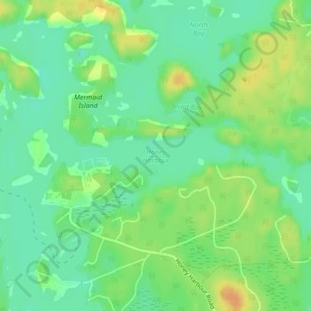
Nombre: Mapa topográfico Honey Harbour, altitud, relieve.
Altitud media: 183 m
Altitud mínima: 169 m
Altitud máxima: 201 m
Otros mapas topográficos
Haga clic en un mapa para ver su topografía, su altitud y su relieve.
Llanberris Island
Canada > Ontario > Muskoka District > Georgian Bay Township
Llanberris Island, Georgian Bay Township, District Municipality of Muskoka, Muskoka District, Central Ontario, Ontario, Canada
Altitud media: 187 m
Go Home Lake
Canada > Ontario > Muskoka District > Georgian Bay Township
Go Home Lake, Georgian Bay Township, District Municipality of Muskoka, Muskoka District, Central Ontario, Ontario, Canada
Altitud media: 192 m
Rose Island
Canada > Ontario > Muskoka District > Georgian Bay Township
Rose Island, Georgian Bay Township, District Municipality of Muskoka, Muskoka District, Central Ontario, Ontario, Canada
Altitud media: 180 m