
Mapa topográfico West Schuyler
Mapa interactivo
Haga clic en el mapa para ver la altitud.
Acerca de este mapa
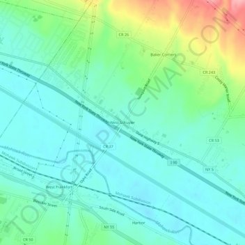
Nombre: Mapa topográfico West Schuyler, altitud, relieve.
Altitud media: 144 m
Altitud mínima: 113 m
Altitud máxima: 235 m
Otros mapas topográficos
Haga clic en un mapa para ver su topografía, su altitud y su relieve.
North Frankfort
United States > New York > Herkimer County > Town of Schuyler
North Frankfort, Town of Schuyler, Herkimer County, New York, 13357, United States
Altitud media: 177 m
Johnson Corners
United States > New York > Herkimer County > Town of Schuyler
Johnson Corners, Town of Schuyler, Herkimer County, New York, United States
Altitud media: 230 m
Baker Corners
United States > New York > Herkimer County > Town of Schuyler
Baker Corners, Town of Schuyler, Herkimer County, New York, 13504, United States
Altitud media: 181 m
East Schuyler
United States > New York > Herkimer County > Town of Schuyler
East Schuyler, Town of Schuyler, Herkimer County, New York, 13340, United States
Altitud media: 159 m