
Gracias por apoyar a este sitio ❤️
Haz una donación
Haz una donación
Mapa topográfico Poxstall
Haga clic en el mapa para ver la altitud.
Gracias por apoyar a este sitio ❤️
Haz una donación
Haz una donación
Poxstall
Das in der Wiesentalb gelegene Dorf liegt etwa dreieinhalb Kilometer westsüdwestlich des Ortszentrums von Ebermannstadt auf einer Höhe von 392 m ü. NHN.
Gracias por apoyar a este sitio ❤️
Haz una donación
Haz una donación
Acerca de este mapa
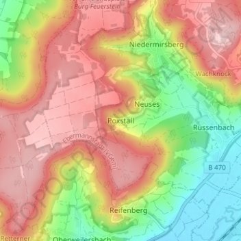
Nombre: Mapa topográfico Poxstall, altitud, relieve.
Altitud media: 417 m
Altitud mínima: 282 m
Altitud máxima: 530 m
Gracias por apoyar a este sitio ❤️
Haz una donación
Haz una donación
Otros mapas topográficos
Haga clic en un mapa para ver su topografía, su altitud y su relieve.
Breitenbach
Deutschland > Bayern > Landkreis Forchheim > Ebermannstadt > Breitenbach
Altitud media: 368 m