
Mapa topográfico Bellingham
Mapa interactivo
Haga clic en el mapa para ver la altitud.
Acerca de este mapa
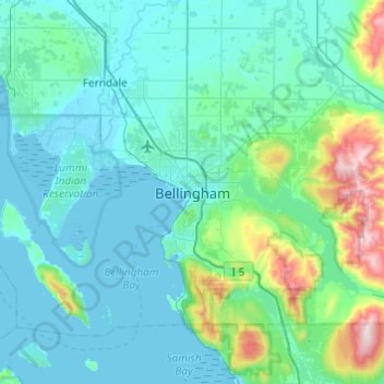
Nombre: Mapa topográfico Bellingham, altitud, relieve.
Altitud media: 129 m
Altitud mínima: -1 m
Altitud máxima: 1.002 m
According to the United States Census Bureau, the city has a total area of 28.90 square miles (74.85 km2), of which, 27.08 square miles (70.14 km2) is land and 1.82 square miles (4.71 km2) is water. The lowest elevations are at sea level along the waterfront. Alabama Hill is one of the higher points in the city at about 500 feet (150 m). Elevations of 800 feet (240 m) are found near Yew Street Hill north of Lake Padden and near Galbraith Mountain. South and eastward of the city limits are taller foothills of the North Cascades mountains. Mount Baker is the largest peak in the local area, with a summit elevation of 10,778 feet (3,285 m) that is only 31 miles (50 km) from Bellingham Bay. Mount Baker is visible from many parts of the city and western Whatcom County. Lake Whatcom forms part of the eastern boundary of the city, while many smaller lakes and wetland areas are found around the region.
Otros mapas topográficos
Haga clic en un mapa para ver su topografía, su altitud y su relieve.
Whatcom Falls Park
United States > Washington > Whatcom County > Bellingham
Whatcom Falls Park, Bellingham, Whatcom County, Washington, United States
Altitud media: 75 m