
Mapa topográfico Austin
Mapa interactivo
Haga clic en el mapa para ver la altitud.
Acerca de este mapa
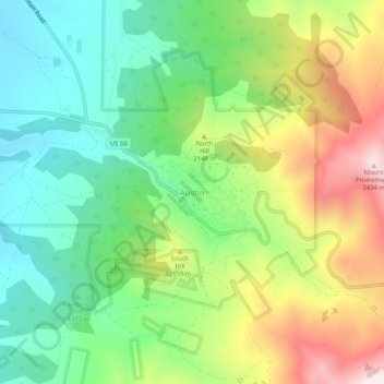
Nombre: Mapa topográfico Austin, altitud, relieve.
Lugar: Austin, Lander County, Nevada, United States (39.47326 -117.08954 39.51326 -117.04954)
Altitud media: 2.076 m
Altitud mínima: 1.841 m
Altitud máxima: 2.464 m
Austin is an unincorporated small town in, and former county seat of, Lander County, Nevada, United States. In 2020, the census-designated place of Austin had a population of 167. It is located on the western slopes of the Toiyabe Range at an elevation of 6,575 feet (2,004 m). U.S. Route 50 passes through the town.
Otros mapas topográficos
Haga clic en un mapa para ver su topografía, su altitud y su relieve.
Kingston
United States > Nevada > Lander County
Kingston, Lander County, Nevada, United States
Altitud media: 1.964 m
Battle Mountain
United States > Nevada > Lander County
Battle Mountain, Lander County, Nevada, United States
Altitud media: 1.376 m