
Mapa topográfico Bochum
Mapa interactivo
Haga clic en el mapa para ver la altitud.
Acerca de este mapa
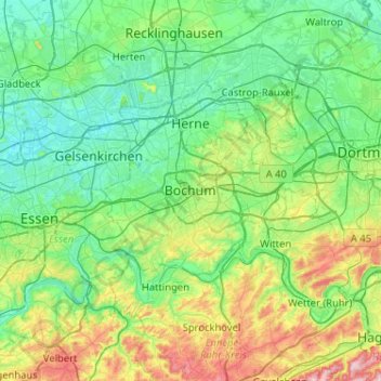
Nombre: Mapa topográfico Bochum, altitud, relieve.
Lugar: Bochum, North Rhine-Westphalia, 44787, Germany (51.32181 7.05966 51.64181 7.37966)
Altitud media: 107 m
Altitud mínima: 28 m
Altitud máxima: 374 m
The city lies on the low rolling hills of Bochum land ridge (Bochumer Landrücken), part of the Ruhrhöhen (highest elevations) between the Ruhr and Emscher rivers at the border of the southern and northern Ruhr coal region. The highest point of the city is at Kemnader Straße (Kemnader Street) in Stiepel at 196 metres (643 ft) above sea level; the lowest point is 43 metres (141 ft) at the Blumenkamp in Hordel.
Otros mapas topográficos
Haga clic en un mapa para ver su topografía, su altitud y su relieve.
Bochum-Südwest
Germany > North Rhine-Westphalia > Bochum
Bochum-Südwest, Bochum, North Rhine-Westphalia, Germany
Altitud media: 115 m
Bochum-Mitte
Germany > North Rhine-Westphalia > Bochum
Bochum-Mitte, Bochum, North Rhine-Westphalia, Germany
Altitud media: 91 m
Bochum-Süd
Germany > North Rhine-Westphalia > Bochum
Bochum-Süd, Bochum, North Rhine-Westphalia, Germany
Altitud media: 115 m
Wattenscheid
Germany > North Rhine-Westphalia > Bochum > Wattenscheid
Wattenscheid, Bochum-Wattenscheid, Bochum, North Rhine-Westphalia, 44866, Germany
Altitud media: 68 m