
Mapa topográfico Cortina d'Ampezzo
Mapa interactivo
Haga clic en el mapa para ver la altitud.
Acerca de este mapa
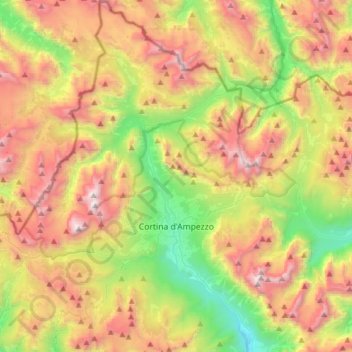
Nombre: Mapa topográfico Cortina d'Ampezzo, altitud, relieve.
Lugar: Cortina d'Ampezzo, Belluno, Veneto, 32043, Italy (46.46177 11.98854 46.67500 12.25759)
Altitud media: 1.974 m
Altitud mínima: 972 m
Altitud máxima: 3.206 m
Among the surrounding mountains are Tofane to the west, Pomagagnon to the north, Cristallo to the northeast, Faloria and Sorapiss to the east, and Becco di Mezzodì, Croda da Lago and Cinque Torri to the south. Monte Antelao (Nantelou in Ladin) is at 3264 m the highest mountain in the Ampezzo Dolomites and the second highest in the Dolomites. When the weather is good, Monte Antelao is clearly visible from the rive in Trieste on the Adriatic Sea. The town centre is located at an elevation of 1,224 metres (4,016 ft), the closest high peak is that of Tofana di Mezzo, which towers at 3,244 metres (10,643 ft). There are numerous fast flowing rivers, streams and small lakes in the territory, such as the Ghedina, Pianozes and d'Ajal, which fill particularly during the summer snow-melt season. Fauna include marmots, roe deer, chamois and hares and, on occasion, wolves, bears and lynx. Much of the area of Cortina is part of the "Natural Park of the Ampezzo Dolomites".
Otros mapas topográficos
Haga clic en un mapa para ver su topografía, su altitud y su relieve.
Cibiana di Cadore
Cibiana di Cadore, Belluno, Veneto, 32040, Italy
Altitud media: 1.460 m
Pieve d'Alpago
Pieve d'Alpago, Alpago, Belluno, Veneto, 32016, Italy
Altitud media: 879 m
Borgo Valbelluna
Borgo Valbelluna, Belluno, Veneto, Italy
Altitud media: 578 m
Santa Croce del Lago
Italy > Veneto > Belluno > Farra d'Alpago
Santa Croce del Lago, Farra d'Alpago, Alpago, Belluno, Veneto, 32016, Italy
Altitud media: 730 m
Lago di Corlo
Italy > Veneto > Belluno > Rocca d'Arsiè
Lago di Corlo, Rocca d'Arsiè, Arsiè, Belluno, Veneto, Italy
Altitud media: 592 m
Colle Santa Lucia
Colle Santa Lucia, Belluno, Veneto, Italy
Altitud media: 1.728 m
Falzarego Pass
Italy > Veneto > Belluno > Cortina d'Ampezzo
Falzarego Pass, Cortina d'Ampezzo, Belluno, Veneto, Italy
Altitud media: 2.179 m
Valparola Pass
Valparola Pass, Livinallongo del Col di Lana, Belluno, Veneto, Italy
Altitud media: 2.199 m
Selva di Cadore
Selva di Cadore, Belluno, Veneto, Italy
Altitud media: 1.696 m
Misurina
Italy > Veneto > Belluno > Auronzo di Cadore
Misurina, Auronzo di Cadore, Belluno, Veneto, Italy
Altitud media: 1.954 m
Monte Piana
Italy > Veneto > Belluno > Auronzo di Cadore
Monte Piana, Auronzo di Cadore, Belluno, Veneto, Italy
Altitud media: 1.850 m
Zwölferkofel - Croda dei Toni
Italy > Veneto > Belluno > Auronzo di Cadore
Zwölferkofel - Croda dei Toni, Auronzo di Cadore, Belluno, Veneto, Italy
Altitud media: 2.367 m
Pocol
Italy > Veneto > Belluno > Cortina d'Ampezzo
Pocol, Cortina d'Ampezzo, Belluno, Veneto, 32043, Italy
Altitud media: 1.448 m
Tre Cime di Lavaredo - Drei Zinnen
Italy > Veneto > Belluno > Auronzo di Cadore
Tre Cime di Lavaredo - Drei Zinnen, Auronzo di Cadore, Pustertal - Val Pusteria, Belluno, Veneto, 39034, Italy
Altitud media: 2.242 m
Ponte nelle Alpi
Ponte nelle Alpi, Belluno, Veneto, 32014, Italy
Altitud media: 739 m
Gruppo del Pomagagnon
Italy > Veneto > Belluno > Cortina d'Ampezzo
Gruppo del Pomagagnon, Cortina d'Ampezzo, Belluno, Veneto, 32043, Italy
Altitud media: 1.758 m
Pieve di Cadore
Italy > Veneto > Belluno > Pieve di Cadore > Pieve di Cadore
Pieve di Cadore, Belluno, Veneto, 32044, Italy
Altitud media: 1.116 m
Cinque Torri
Italy > Veneto > Belluno > Cortina d'Ampezzo
Cinque Torri, Cortina d'Ampezzo, Belluno, Veneto, Italy
Altitud media: 2.071 m
Mottes
Italy > Veneto > Belluno > Rivamonte Agordino > Rivamonte Agordino
Mottes, Rivamonte Agordino, Belluno, Veneto, 32021, Italy
Altitud media: 994 m