
Mapa topográfico Conconully
Haga clic en el mapa para ver la altitud.
Acerca de este mapa
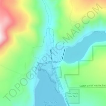
Nombre: Mapa topográfico Conconully, altitud, relieve.
Altitud media: 832 m
Altitud mínima: 691 m
Altitud máxima: 1.161 m
Otros mapas topográficos
Haga clic en un mapa para ver su topografía, su altitud y su relieve.
Goat Peak
United States > Washington > Okanogan County
Goat Peak is a 7,001-foot (2,134 m) peak in the North Cascades of Washington, United States. The summit offers broad views of the Methow River valley, as well as many of the other prominent cascade peaks including glaciated Silver Star Mountain. A working US Forest Service fire lookout is located on the…
Altitud media: 1.658 m