
Mapa topográfico Volcán Parinacota
Mapa interactivo
Haga clic en el mapa para ver la altitud.
Volcán Parinacota
Parinacota (in Hispanicized spelling), Parina Quta or Parinaquta is a dormant stratovolcano on the border of Bolivia and Chile. Together with Pomerape it forms the Nevados de Payachata volcanic chain. Part of the Central Volcanic Zone of the Andes, its summit reaches an elevation of 6,380 metres (20,930 ft) above sea level. The symmetrical cone is capped by a summit crater with widths of 1 kilometre (0.62 mi) or 500 metres (1,600 ft). Farther down on the southern slopes lie three parasitic centres known as the Ajata cones. These cones have generated lava flows. The volcano overlies a platform formed by lava domes and andesitic lava flows.
Acerca de este mapa
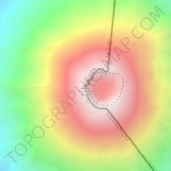
Nombre: Mapa topográfico Volcán Parinacota, altitud, relieve.
Altitud media: 5.808 m
Altitud mínima: 5.161 m
Altitud máxima: 6.341 m
Otros mapas topográficos
Haga clic en un mapa para ver su topografía, su altitud y su relieve.
Salar de Surire
Chile > Arica y Parinacota Region > Provincia de Parinacota > Putre
Altitud media: 4.359 m