
Mapa topográfico Lake Bolsena
Mapa interactivo
Haga clic en el mapa para ver la altitud.
Lake Bolsena
Elevations on the north of the lake are the highest, with a maximum of 702 m (2,303 ft). As the lake is at 305 m (1,001 ft), no hill is more than 397 m (1,302 ft) higher than it. On the northern rim of the caldera is San Lorenzo Nuovo ("New Saint Lawrence"), which was moved from an older site (a hypothetical San Lorenzo Vecchio, "Old Saint Lawrence") further down the slope to avoid malaria. The northern shore of the lake once featured marshes, breeding grounds for the mosquitos that carry the disease. Currently it is agricultural. At the site of old San Lorenzo are Etruscan antiquities. To the north of San Lorenzo Nuovo and the caldera rim is Acquapendente.
Acerca de este mapa
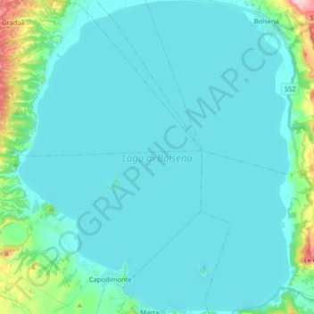
Nombre: Mapa topográfico Lake Bolsena, altitud, relieve.
Lugar: Lake Bolsena, Viterbo, Lazio, Italy (42.53325 11.85721 42.65198 11.99712)
Altitud media: 328 m
Altitud mínima: 297 m
Altitud máxima: 574 m
Otros mapas topográficos
Haga clic en un mapa para ver su topografía, su altitud y su relieve.