
Mapa topográfico Ricketts Glen State Park
Mapa interactivo
Haga clic en el mapa para ver la altitud.
Acerca de este mapa
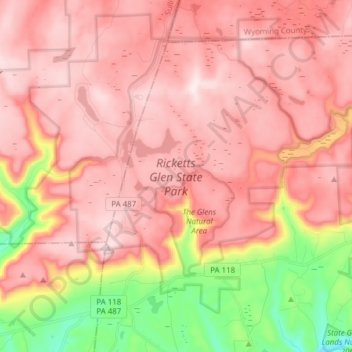
Nombre: Mapa topográfico Ricketts Glen State Park, altitud, relieve.
Altitud media: 588 m
Altitud mínima: 282 m
Altitud máxima: 751 m
The state's original plans for the new park included building an inn, an 18-hole golf course and country club, and a winter sports complex for skiing, ice boating, and tobogganing, as well as a beach with bathing facilities, cabins, and a tent camping area. Only the last three were actually built, all south of Lake Jean; the Hayfield area north of Lake Jean was to have had the facilities for golf and tennis, and the inn and winter sports complex were to have been atop Cherry Ridge, at an elevation of 2,461 feet (750 m).
Otros mapas topográficos
Haga clic en un mapa para ver su topografía, su altitud y su relieve.
Lake Leigh Dam (defunct)
United States > Pennsylvania > Luzerne County > Fairmount Township
Lake Leigh Dam (defunct), Fairmount Township, Luzerne County, Pennsylvania, United States
Altitud media: 672 m
Red Rock
United States > Pennsylvania > Luzerne County > Fairmount Township
Red Rock, Fairmount Township, Luzerne County, Pennsylvania, United States
Altitud media: 438 m