
Mapa topográfico Eyjafjallajökull
Mapa interactivo
Haga clic en el mapa para ver la altitud.
Acerca de este mapa
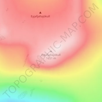
Nombre: Mapa topográfico Eyjafjallajökull, altitud, relieve.
Altitud media: 1.459 m
Altitud mínima: 1.162 m
Altitud máxima: 1.628 m
Eyjafjallajökull (Icelandic: [ˈeiːjaˌfjat͡ɬaˌjœːkʏt͡ɬ] ; lit. 'glacier of the mountains of the islands'), sometimes referred to by the numeronym E15, is one of the smaller ice caps of Iceland, north of Skógar and west of Mýrdalsjökull. The ice cap covers the caldera of a volcano with a summit elevation of 1,651 metres (5,417 ft). The volcano has erupted relatively frequently since the Last Glacial Period, most recently in 2010, when, although relatively small for a volcanic eruption, it caused enormous disruption to air travel across northern and western Europe for a week.
Otros mapas topográficos
Haga clic en un mapa para ver su topografía, su altitud y su relieve.
Skogafoss
Skogafoss, Rangárþing eystra, Southern Region, Iceland
Altitud media: 145 m
Eyjafjallajökull
Eyjafjallajökull, Rangárþing eystra, Southern Region, Iceland
Altitud media: 821 m