
Mapa topográfico Winona Lake
Mapa interactivo
Haga clic en el mapa para ver la altitud.
Acerca de este mapa
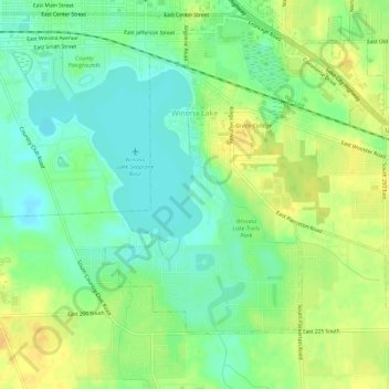
Nombre: Mapa topográfico Winona Lake, altitud, relieve.
Lugar: Winona Lake, Kosciusko County, Indiana, 46590, United States (41.20328 -85.83538 41.23349 -85.77916)
Altitud media: 257 m
Altitud mínima: 243 m
Altitud máxima: 272 m
Otros mapas topográficos
Haga clic en un mapa para ver su topografía, su altitud y su relieve.
Syracuse
United States > Indiana > Kosciusko County
Syracuse, Kosciusko County, Indiana, United States
Altitud media: 267 m
Pierceton
United States > Indiana > Kosciusko County
Pierceton, Kosciusko County, Indiana, United States
Altitud media: 280 m
Warsaw
United States > Indiana > Kosciusko County
Warsaw, Kosciusko County, Indiana, 46580, United States
Altitud media: 256 m
Tippecanoe Lake
United States > Indiana > Kosciusko County
Tippecanoe Lake, Kosciusko County, Indiana, United States
Altitud media: 263 m
Atwood
United States > Indiana > Kosciusko County
Atwood, Kosciusko County, Indiana, 46502, United States
Altitud media: 246 m
Warsaw
United States > Indiana > Kosciusko County > Warsaw > Warsaw
Warsaw, Kosciusko County, Indiana, 4650, United States
Altitud media: 255 m
Highlands Park
United States > Indiana > Kosciusko County > Highlands Park
Highlands Park, Kosciusko County, Indiana, 46852, United States
Altitud media: 262 m
Lake Wawasee
United States > Indiana > Kosciusko County > Syracuse
Lake Wawasee, Syracuse, Kosciusko County, Indiana, 46567, United States
Altitud media: 267 m
Silver Point
United States > Indiana > Kosciusko County > Forest Glen
Silver Point, Forest Glen, Kosciusko County, Indiana, 46538, United States
Altitud media: 264 m