
Mapa topográfico Wilhelminaberg
Mapa interactivo
Haga clic en el mapa para ver la altitud.
Acerca de este mapa
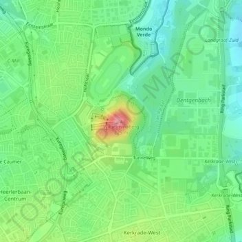
Nombre: Mapa topográfico Wilhelminaberg, altitud, relieve.
Lugar: Wilhelminaberg, Landgraaf, Limburg, Nederland, 6372VG, Nederland (50.87555 6.02542 50.87565 6.02552)
Altitud media: 147 m
Altitud mínima: 113 m
Altitud máxima: 212 m
Otros mapas topográficos
Haga clic en un mapa para ver su topografía, su altitud y su relieve.
Brunssummerheide
Nederland > Limburg > Heerlen > Landgraaf
Brunssummerheide, Schachtstraat, Nieuwenhagerheide, Landgraaf, Limburg, Nederland, 6373CH, Nederland
Altitud media: 104 m
Kasteel Strijthagen
Nederland > Limburg > Landgraaf
Kasteel Strijthagen, Rouenhof, Eikske, Landgraaf, Limburg, Nederland, 6372PW, Nederland
Altitud media: 137 m