
Mapa topográfico Nördliche Innenstadt
Mapa interactivo
Haga clic en el mapa para ver la altitud.
Acerca de este mapa
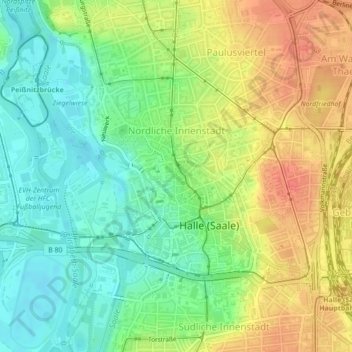
Nombre: Mapa topográfico Nördliche Innenstadt, altitud, relieve.
Altitud media: 97 m
Altitud mínima: 74 m
Altitud máxima: 125 m
Otros mapas topográficos
Haga clic en un mapa para ver su topografía, su altitud y su relieve.
Heide-Süd
Deutschland > Sachsen-Anhalt > Halle (Saale)
Heide-Süd, Halle (Saale), Sachsen-Anhalt, Deutschland
Altitud media: 92 m
Gottfried-Keller-Siedlung
Deutschland > Sachsen-Anhalt > Halle (Saale)
Gottfried-Keller-Siedlung, Halle (Saale), Sachsen-Anhalt, 06118, Deutschland
Altitud media: 106 m
Reideburg
Deutschland > Sachsen-Anhalt > Halle (Saale)
Reideburg, Halle (Saale), Sachsen-Anhalt, Deutschland
Altitud media: 98 m
Kanena
Deutschland > Sachsen-Anhalt > Halle (Saale) > Kanena
Kanena, Halle (Saale), Sachsen-Anhalt, 06116, Deutschland
Altitud media: 97 m
Diemitz
Deutschland > Sachsen-Anhalt > Halle (Saale)
Diemitz, Halle (Saale), Sachsen-Anhalt, Deutschland
Altitud media: 109 m
Paulusviertel
Deutschland > Sachsen-Anhalt > Halle (Saale)
Paulusviertel, Halle (Saale), Sachsen-Anhalt, 06114, Deutschland
Altitud media: 106 m
Ammendorf/Beesen
Deutschland > Sachsen-Anhalt > Halle (Saale)
Ammendorf/Beesen, Halle (Saale), Sachsen-Anhalt, 06132, Deutschland
Altitud media: 99 m