
Mapa topográfico Arnhem
Mapa interactivo
Haga clic en el mapa para ver la altitud.
Acerca de este mapa
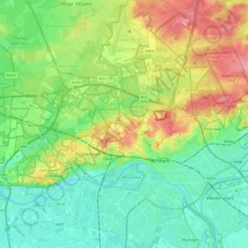
Nombre: Mapa topográfico Arnhem, altitud, relieve.
Lugar: Arnhem, Arnheim, Geldern, Niederlande (51.93346 5.80296 52.07789 5.99034)
Altitud media: 36 m
Altitud mínima: 1 m
Altitud máxima: 103 m
Otros mapas topográficos
Haga clic en un mapa para ver su topografía, su altitud y su relieve.