
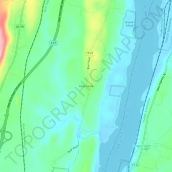
Mapa topográfico Otter Hook
Mapa interactivo
Haga clic en el mapa para ver la altitud.
Acerca de este mapa
Nombre: Mapa topográfico Otter Hook, altitud, relieve.
Altitud media: 34 m
Altitud mínima: -2 m
Altitud máxima: 155 m
Otros mapas topográficos
Haga clic en un mapa para ver su topografía, su altitud y su relieve.
Deans Mill
United States > New York > Greene County > Town of New Baltimore
Deans Mill, Town of New Baltimore, Greene County, New York, 12143, United States
Altitud media: 101 m
Grapeville
United States > New York > Greene County > Town of New Baltimore
Grapeville, Town of New Baltimore, Greene County, New York, 12176, United States
Altitud media: 215 m
Medway
United States > New York > Greene County > Town of New Baltimore
Medway, Town of New Baltimore, Greene County, New York, 12042, United States
Altitud media: 208 m
Hannacroix
United States > New York > Greene County > Town of New Baltimore
Hannacroix, Town of New Baltimore, Greene County, New York, 12124, United States
Altitud media: 69 m
Paradise Hill
United States > New York > Greene County > Town of New Baltimore
Paradise Hill, Town of New Baltimore, Greene County, New York, 12042, United States
Altitud media: 188 m
Roberts Hill
United States > New York > Greene County > Town of New Baltimore
Roberts Hill, Town of New Baltimore, Greene County, New York, 12192, United States
Altitud media: 103 m