
Mapa topográfico Cedarville Station
Mapa interactivo
Haga clic en el mapa para ver la altitud.
Acerca de este mapa
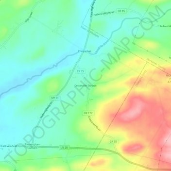
Nombre: Mapa topográfico Cedarville Station, altitud, relieve.
Altitud media: 412 m
Altitud mínima: 362 m
Altitud máxima: 504 m
Otros mapas topográficos
Haga clic en un mapa para ver su topografía, su altitud y su relieve.
Chepachet
United States > New York > Herkimer County > Town of Winfield
Chepachet, Town of Winfield, Herkimer County, New York, United States
Altitud media: 408 m
Birmingham Corners
United States > New York > Herkimer County > Town of Winfield
Birmingham Corners, Town of Winfield, Herkimer County, New York, 13491, United States
Altitud media: 417 m
Woods Corners
United States > New York > Herkimer County > Town of Winfield
Woods Corners, Town of Winfield, Herkimer County, New York, 13491, United States
Altitud media: 418 m