
Mapa topográfico Clowes Wood
Mapa interactivo
Haga clic en el mapa para ver la altitud.
Acerca de este mapa
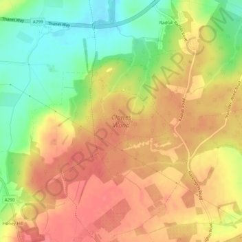
Nombre: Mapa topográfico Clowes Wood, altitud, relieve.
Lugar: Clowes Wood, Blean, Canterbury, Kent, England, United Kingdom (51.31237 1.03234 51.34191 1.07062)
Altitud media: 53 m
Altitud mínima: 15 m
Altitud máxima: 78 m
Otros mapas topográficos
Haga clic en un mapa para ver su topografía, su altitud y su relieve.
Honey Hill
United Kingdom > England > Kent > Canterbury > Blean
Honey Hill, Blean, Canterbury, Kent, England, CT5 3BP, United Kingdom
Altitud media: 61 m