
Mapa topográfico Palestine
Mapa interactivo
Haga clic en el mapa para ver la altitud.
Acerca de este mapa
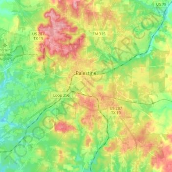
Nombre: Mapa topográfico Palestine, altitud, relieve.
Lugar: Palestine, Anderson County, Texas, United States (31.69527 -95.72426 31.80843 -95.56776)
Altitud media: 136 m
Altitud mínima: 85 m
Altitud máxima: 204 m
About 40% of the content from the 2003 Space Shuttle Columbia disaster was recovered. seven astronauts were killed in the accident.[19] Debris from Columbia was found in and outside Palestine and other East Texas towns.[20][21] Palestine's NASA Columbia Scientific Balloon Facility (renamed in honor of the shuttle crew), has flown 1,700 high-altitude balloons for universities and research agencies.
Otros mapas topográficos
Haga clic en un mapa para ver su topografía, su altitud y su relieve.
Daly Mountain
United States > Texas > Anderson County > Neches
Daly Mountain, Neches, Anderson County, Texas, 75779, United States
Altitud media: 128 m
Fosterville
United States > Texas > Anderson County
Fosterville, Anderson County, Texas, United States
Altitud media: 133 m
Yard
United States > Texas > Anderson County
Yard, Anderson County, Texas, United States
Altitud media: 78 m