
Mapa topográfico Norvin Green State Forest
Mapa interactivo
Haga clic en el mapa para ver la altitud.
Acerca de este mapa
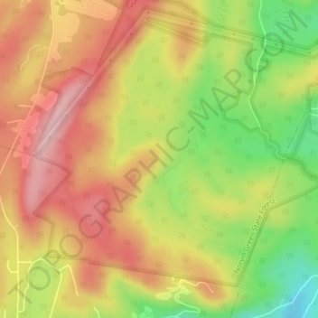
Nombre: Mapa topográfico Norvin Green State Forest, altitud, relieve.
Altitud media: 262 m
Altitud mínima: 143 m
Altitud máxima: 355 m
Otros mapas topográficos
Haga clic en un mapa para ver su topografía, su altitud y su relieve.
Echo Lake
United States > New Jersey > Passaic County > West Milford
Echo Lake, West Milford, Passaic County, New Jersey, 07480, United States
Altitud media: 305 m
Moe
United States > New Jersey > Passaic County > West Milford
Moe, West Milford, Passaic County, New Jersey, 07421, United States
Altitud media: 354 m
Pinecrest Lake
United States > New Jersey > Passaic County > West Milford
Pinecrest Lake, West Milford, Passaic County, New Jersey, United States
Altitud media: 277 m
Oak Ridge
United States > New Jersey > Passaic County > West Milford
Oak Ridge, West Milford, Passaic County, New Jersey, 07438, United States
Altitud media: 277 m