
Gracias por apoyar a este sitio ❤️
Haz una donación
Haz una donación
Mapa topográfico Eschlipp
Haga clic en el mapa para ver la altitud.
Gracias por apoyar a este sitio ❤️
Haz una donación
Haz una donación
Eschlipp
Das im Süden der Heiligenstädter Flächenalb gelegene Dorf[2] befindet sich etwa vier Kilometer nordwestlich des Ortszentrums von Ebermannstadt auf einer Höhe von 474 m ü. NHN.[3]
Gracias por apoyar a este sitio ❤️
Haz una donación
Haz una donación
Acerca de este mapa
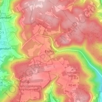
Nombre: Mapa topográfico Eschlipp, altitud, relieve.
Altitud media: 464 m
Altitud mínima: 320 m
Altitud máxima: 537 m
Gracias por apoyar a este sitio ❤️
Haz una donación
Haz una donación
Otros mapas topográficos
Haga clic en un mapa para ver su topografía, su altitud y su relieve.
Breitenbach
Deutschland > Bayern > Landkreis Forchheim > Ebermannstadt > Breitenbach
Altitud media: 368 m