
Mapa topográfico Port Jefferson
Mapa interactivo
Haga clic en el mapa para ver la altitud.
Port Jefferson
It wasn't until 1836 that the local leadership truly initiated the community's transition from a swampish hamlet to a bustling port town. Twenty-two acres of the harborfront, which flooded with the tides, were brought to a stable elevation with the construction of a causeway. Concurrently, the village was rechristened from "Drowned Meadow" to "Port Jefferson" The name choice was in honor of Thomas Jefferson.
Acerca de este mapa
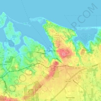
Nombre: Mapa topográfico Port Jefferson, altitud, relieve.
Altitud media: 26 m
Altitud mínima: -4 m
Altitud máxima: 82 m