
Mapa topográfico Alfeld (Leine)
Mapa interactivo
Haga clic en el mapa para ver la altitud.
Acerca de este mapa
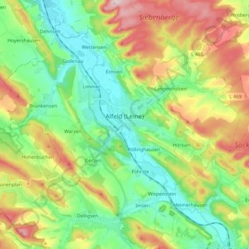
Nombre: Mapa topográfico Alfeld (Leine), altitud, relieve.
Altitud media: 191 m
Altitud mínima: 78 m
Altitud máxima: 390 m
Otros mapas topográficos
Haga clic en un mapa para ver su topografía, su altitud y su relieve.
Detfurth
Germany > Lower Saxony > Landkreis Hildesheim > Bad Salzdetfurth
Detfurth, Bad Salzdetfurth, Landkreis Hildesheim, Lower Saxony, 31162, Germany
Altitud media: 158 m
Hildesheim
Germany > Lower Saxony > Landkreis Hildesheim
Hildesheim, Landkreis Hildesheim, Lower Saxony, Germany
Altitud media: 120 m
Nordstemmen
Germany > Lower Saxony > Landkreis Hildesheim
Nordstemmen, Landkreis Hildesheim, Lower Saxony, 31171, Germany
Altitud media: 100 m