
Mapa topográfico Shangri-La
Mapa interactivo
Haga clic en el mapa para ver la altitud.
Acerca de este mapa
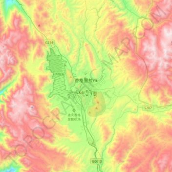
Nombre: Mapa topográfico Shangri-La, altitud, relieve.
Altitud media: 3.678 m
Altitud mínima: 3.173 m
Altitud máxima: 4.532 m
Shangri-La has either a dry-winter, warm-summer humid continental climate (Köppen climate classification: Dwb), or a dry-winter subtropical highland climate (Köppen climate classification: Cwb), both of which are unusually cool by Yunnan standards due to the high elevation, which ranges between 2,700 and 3,500 metres (8,900 and 11,500 ft). Winters are chilly but sunny, with a January 24-hour average temperature of −2.3 °C (27.9 °F), while summers are cool, with a July 24-hour average temperature of 13.9 °C (57.0 °F), and feature frequent rain; more than 70% of the annual precipitation is delivered from June to September. The annual mean is 6.32 °C (43.4 °F). Except during the summer, nights are usually sharply cooler than the days. Despite the dryness of the winter, the small amount of precipitation is generally sufficient to cause major transportation dislocations and isolate the area between November and March.
Otros mapas topográficos
Haga clic en un mapa para ver su topografía, su altitud y su relieve.