
Mapa topográfico Bad Hersfeld
Mapa interactivo
Haga clic en el mapa para ver la altitud.
Acerca de este mapa
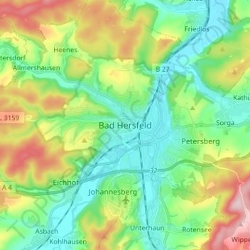
Nombre: Mapa topográfico Bad Hersfeld, altitud, relieve.
Altitud media: 281 m
Altitud mínima: 193 m
Altitud máxima: 466 m
The Flugplatz Johannesberg has the status of Special Airfield. The runway, some 671 m long and 18 m wide, is paved with asphalt and oriented in a north–south direction. The airfield lies on the Johannesberg in the like-named outlying centre at an elevation of 284 m above sea level.
Otros mapas topográficos
Haga clic en un mapa para ver su topografía, su altitud y su relieve.
Hohenroda
Germany > Hesse > Landkreis Hersfeld-Rotenburg
Hohenroda, Landkreis Hersfeld-Rotenburg, Hesse, 36284, Germany
Altitud media: 341 m
Heringen (Werra)
Germany > Hesse > Landkreis Hersfeld-Rotenburg
Heringen (Werra), Landkreis Hersfeld-Rotenburg, Hesse, 36266, Germany
Altitud media: 294 m
Bebra
Germany > Hesse > Landkreis Hersfeld-Rotenburg
Bebra, Landkreis Hersfeld-Rotenburg, Hesse, 36179, Germany
Altitud media: 312 m
Heenes
Germany > Hesse > Landkreis Hersfeld-Rotenburg
Heenes, Bad Hersfeld, Landkreis Hersfeld-Rotenburg, Hesse, Germany
Altitud media: 310 m
Haunetal
Germany > Hesse > Landkreis Hersfeld-Rotenburg
Haunetal, Landkreis Hersfeld-Rotenburg, Hesse, 36166, Germany
Altitud media: 313 m