
Mapa topográfico Isla Alejandro Selkirk
Mapa interactivo
Haga clic en el mapa para ver la altitud.
Acerca de este mapa
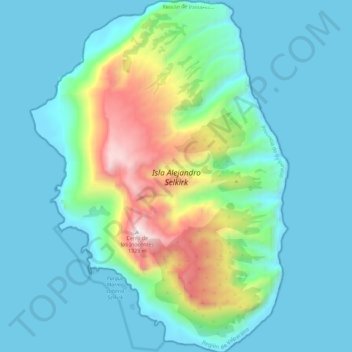
Nombre: Mapa topográfico Isla Alejandro Selkirk, altitud, relieve.
Altitud media: 265 m
Altitud mínima: -4 m
Altitud máxima: 1.352 m
Alejandro Selkirk has a subtropical climate, moderated by the cold Humboldt Current and the southeast trade winds. Temperatures range from 3 °C (37 °F) to 34 °C (93 °F), with an annual mean of 15.4 °C (59.7 °F). Higher elevations are generally cooler. Average annual precipitation is 1,081 mm (42.6 in), varying from 318 mm (12.5 in) to 1,698 mm (66.9 in) year to year. Rainfall is higher in the winter months, and varies with elevation and exposure; elevations above 500 m (1,640 ft) experience almost daily rainfall.
Otros mapas topográficos
Haga clic en un mapa para ver su topografía, su altitud y su relieve.
Robinson Crusoe Island
Chile > Valparaiso Region > Juan Fernández
Robinson Crusoe Island, Juan Fernández, Provincia de Valparaíso, Valparaiso Region, Chile
Altitud media: 44 m