
Mapa topográfico Kayts
Mapa interactivo
Haga clic en el mapa para ver la altitud.
Acerca de este mapa
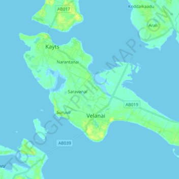
Nombre: Mapa topográfico Kayts, altitud, relieve.
Lugar: Kayts, Saravanai, Jaffna District, Northern Province, Sri Lanka (9.61235 79.84043 9.70347 79.98518)
Altitud media: 2 m
Altitud mínima: -2 m
Altitud máxima: 13 m
Velani is located at 9°24′N 79°32′E / 9.40°N 79.54°E / 9.40; 79.54. It is surrounded by the Palk Strait and at a distance of 6 kilometres (3.7 mi) south-west of Jaffna town. Though most of Velani district is a level plain and also has maximum elevation of 15 metres (49 ft) above mean sea level. The total area of this island is nearly 36 km2.